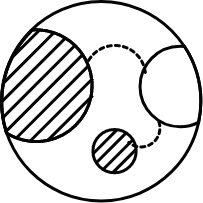

The animation below highlights the datasets produced by TerrAdapt and how they relate to the conservation of regional species and ecosystems under threat from climate change and our expanding human footprint. The animation plays from current to future time periods and follows a hypothetical shift in the range of a species or ecosystem over time, with management considerations and links to TerrAdapt data layers noted at each step.
- TerrAdapt's Scope
Monitor
Project
Prioritize
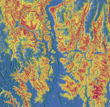
Monitor landscape change. TerrAdapt uses satellite imagery and other data to monitor vegetation dynamics and ecological disturbances (e.g., wildfire, timber harvest, and urban growth) and assess impacts on habitat and connectivity for target species and ecosystems from 1990 to present. Important habitat and connectivity areas are mapped and kept up-to-date automatically (grey areas in the graphic below).
Project range contractions and refugia. TerrAdapt uses future climate and landscape scenarios to project potential impacts to habitat and connectivity for target species and ecosystems out to the year 2100. TerrAdapt identifies areas that may become unsuitable in the future (i.e., range contractions; orange tones in the graphic below) as well as more stable areas that may remain suitable and serve as climatic refugia.
Project range expansions. TerrAdapt uses future climate and landscape scenarios to project areas of potential range expansion (blue tones in the graphic below). Anticipating where range expansions may occur and conserving habitat within and connectivity to such areas is one strategy to help offset habitat loss on the trailing edge of a range shift where the range is contracting.
Project future landscape connectivity. Conserving connectivity between currently suitable habitat and areas of range expansion is critical if species are to track their shifting habitat over time. TerrAdapt projects areas that link current to potential future habitat. These 'climate corridors' follow paths that minimize exposure to the human footprint as well as unsuitable climatic conditions.
Project future risks. TerrAdapt projects future risks relevant to managing habitat for target species and ecosystems. These projections are still under development but may include things like risk of urbanization, risk of timber harvest, and risk of unsuitable future climatic conditions. Anticipating future risks can help to prioritize areas for implementation that are likely to remain effective over time.
Prioritize habitat protection. TerrAdapt uses information from the monitoring and projection layers to identify priority areas for increased habitat protection status. Protection priorities depend on the values of stakeholders. They area currently defined as the largest unprotected cores of the best remaining habitat that is highly connected and occurs within climatic refugia.
Prioritize habitat restoration. TerrAdapt uses information from the monitoring and projection layers to identify priority areas for habitat restoration. Restoration priorities depend on the values of stakeholders. They are currently defined as areas near small cores of currently suitable habitat that occur within climatic refugia. Restoring habitat in these areas would increase core size and connectivity to the larger network.
Prioritize barrier mitigation. TerrAdapt uses information from the monitoring and projection layers to identify priority areas for barrier mitigation. Barrier mitigation priorities depend on the values of stakeholders. They are currently defined as movement barriers that occur within climatic refugia that, if mitigated, would significantly increase connectivity for the network of habitat for the target species or ecosystem.
Monitor. Project. Prioritize. TerrAdapt's monitoring and projection layers provide insight into spatial and temporal dynamics of habitat and connectivity for target species and ecosystems of Cascadia. TerrAdapt's prioritization layers can help managers decide where to invest in new protected areas, habitat restoration, and barrier mitigation to improve the ecological functioning and resilience of regional habitat networks.
TerrAdapt maps, reports, and dashboards have applications throughout the adaptive landscape management cycle as shown in the diagram below. Adaptive management is a proactive and iterative decision process bringing new information about landscape conditions, risks, and trends over time into the implementation of a management plan.
TerrAdapt Integration into Adaptive Management
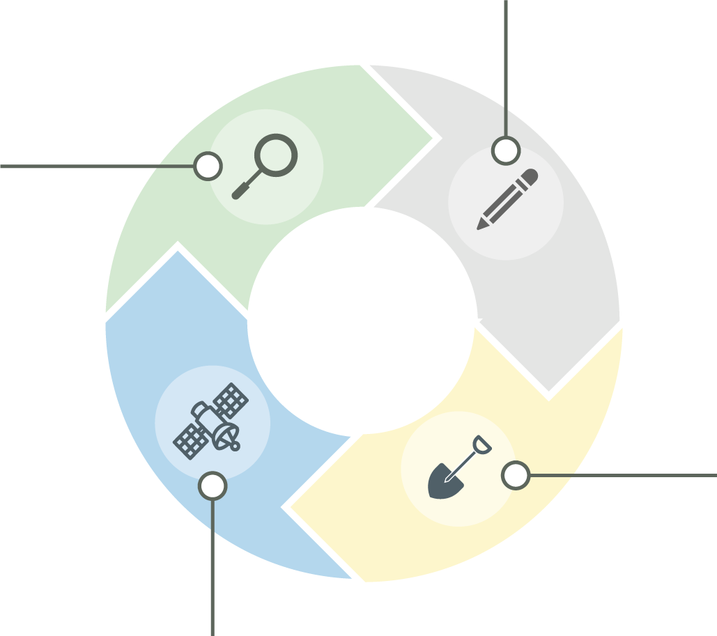
Evaluate
TerrAdapt dynamic dashboards and annual reports provide metrics for evaluation
Plan
TerrAdapt dynamic maps and reports provide up-to-date information to inform conservation planning
Implement
TerrAdapt dynamic maps identify priority areas for implementing habitat restoration, protection, and barrier mitigation
Monitor
TerrAdapt dynamic maps provide monitoring of conditions over time